Пойменная терраса реки Чуя / geographic pointLandscapes and habitats
online plant identification guide
Directories
Region
| Geographic point: | Пойменная терраса реки Чуя |
| Coordinates: | 50° 09′ 59.94″ N, 88° 12′ 52.48″ E (view at maps of Google, OpenStreetMap, Yandex) |
| Administrative location: | Россия, Республика Алтай, Кош-Агачский район, 845 км Чуйского тракта |
| Physiographic location: | Горы Южной Сибири, Алтай, Юго-Восточный Алтай, Чуйская котловина, долина реки Чуя |
| Author: | Марина Скотникова |
Images
Single image is found
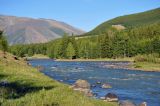 |
 Пойменная терраса реки Чуя Долина реки Чуя у 845 км Чуйского тракта. Видна пойменная терраса и хвойный лес на противоположном берегу. 13.06.2017. summer |
Plants and lichens
Participant
Search
| Feedback | Text to cite the page | To the top |