Маршрут Sočerga - Dvori / geographic pointLandscapes and habitats
online plant identification guide
Directories
Region
| Geographic point: | Маршрут Sočerga - Dvori |
| Coordinates: | 45° 28′ 08″ N, 13° 54′ 27″ E (view at maps of Google, OpenStreetMap, Yandex) |
| Administrative location: | Словения, Прибрежнокарстский регион, община Копер |
| Physiographic location: | Средиземноморье и Переднеазиатские нагорья, Балканский полуостров, Динарское нагорье |
| Author: | Denis Mirin |
Images
Single image is found
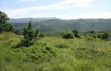 |
 Маршрут Sočerga - Dvori Вторичная остепнённая гарига (господствуют засухоустойчивые травы, присутствуют полукустарнички - чабрецы и др., кустарники и низкие деревья). На дальних склонах видна растительность таких же мест, но без выпаса, - леса из Quercus pubescens, Pinus nigra. 09.05.2014. late spring or early summer |
Plants and lichens
Participant
Search
| Feedback | Text to cite the page | To the top |