Долина реки Шураозень / geographic pointLandscapes and habitats
online plant identification guide
Directories
Region
| Geographic point: | Долина реки Шураозень |
| Coordinates: | 42° 58′ 42.89″ N, 47° 11′ 43.94″ E (view at maps of Google, OpenStreetMap, Yandex) |
| Administrative location: | Россия, Республика Дагестан, Кумторкалинский район |
| Physiographic location: | Кавказ, Большой Кавказ, Восточный Кавказ, бассейн реки Шураозень, долина реки Шураозень |
| Author: | Gennadiy Okatov |
Images
The author of the photos shown here is Ilia Mikheev. These photos are just a part of the complete set of images.
Single image is found
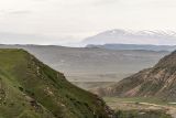 |
 Долина реки Шураозень Вид на долину р. Шураозень. На заднем плане виден Гимринский хребет с высотами более 2000 м. 29.04.2026. spring |
Plants and lichens
Participant
Search
|
|
Feedback | Text to cite the page | To the top |