Яковлевка / geographic pointLandscapes and habitats
online plant identification guide
Directories
Region
| Geographic point: | Яковлевка |
| Coordinates: | 57° 10′ 39″ N, 72° 25′ 18″ E (view at maps of Google, OpenStreetMap, Yandex) |
| Administrative location: | Россия, Омская область |
| Physiographic location: | Западно-Сибирская равнина, бассейн реки Обь, бассейн реки Иртыш, урочище Яковлевка |
| Author: | Святослав Князев |
Description
Равнинный смешанный лес по берегам р. Тевриз состоит преимущественно из березы, осины, липы, с редкими включениями хвойных пород — сосны обыкновенной, сосны сибирской, ели, лиственницы.
Images
From 1 to 2 are shown (2 of 2 found)
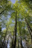 |
 Яковлевка Липняк в пойме р. Тевриз. 21.05.2016. late spring or early summer |
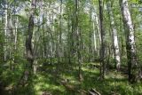 |
Яковлевка Смешанный берёзово-липовый лес в пойме р. Тевриз. 21.05.2016. late spring or early summer |
Plants and lichens
Participant
Search
| Feedback | Text to cite the page | To the top |