Кубалах / geographic pointLandscapes and habitats
online plant identification guide
Directories
Region
| Geographic point: | Кубалах |
| Coordinates: | 72° 26′ 22″ N, 126° 18′ 09″ E (view at maps of Google, OpenStreetMap, Yandex) |
| Administrative location: | Россия, Республика Саха (Якутия), Булунский улус |
| Physiographic location: | Средняя Сибирь, бассейн реки Лена, дельта реки Лена, остров Кубалах-Арыта |
| Author: | Денис Кочетков |
Images
Single image is found
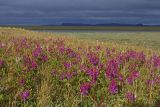 |
 Кубалах Обильное цветение копеечника арктического на песчаных, хорошо дренированных буграх острова; чуть ниже виднеются ивняки. На заднем плане, за протокой, синеют северные отроги Хараулахского хребта. 26.07.2017. summer |
Plants and lichens
Participant
Search
| Feedback | Text to cite the page | To the top |