Окр. посёлка Эльбрус / geographic pointLandscapes and habitats
online plant identification guide
Directories
Region
| Geographic point: | Окр. посёлка Эльбрус |
| Coordinates: | 43° 15′ 21″ N, 42° 38′ 45″ E (view at maps of Google, OpenStreetMap, Yandex) |
| Administrative location: | Россия, Кабардино-Балкарская Республика, Эльбрусский район, окрестности посёлка Эльбрус |
| Physiographic location: | Кавказ, Большой Кавказ, бассейн реки Баксан |
| Author: | Gennadiy Okatov |
Images
The author of the photos shown here is Ilia Mikheev. These photos are just a part of the complete set of images.
Single image is found
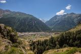 |
 Окр. посёлка Эльбрус Вид на село Эльбрус и долину реки Адылсу. На горизонте просматривается Большой Кавказский хребет и двуглавая вершина горы Ушба. Склоны ущелья реки Ирик на переднем плане покрыты сосновым лесом. 20.08.2023. summer |
Plants and lichens
Participant
Search
|
|
Feedback | Text to cite the page | To the top |