Долина реки Бохморон-Гол / geographic pointLandscapes and habitats
online plant identification guide
Directories
Region
| Geographic point: | Долина реки Бохморон-Гол |
| Coordinates: | 49° 46′ 17″ N, 90° 25′ 22″ E (view at maps of Google, OpenStreetMap, Yandex) |
| Administrative location: | Монголия, аймак Увс, сомон Бухемурен |
| Physiographic location: | Центральная Азия, Монгольское плато, Ачитнурская котловина, долина реки Бохморон-Гол |
| Author: | Марина Скотникова |
Images
From 1 to 2 are shown (2 of 2 found)
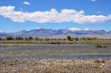 |
 Долина реки Бохморон-Гол Долина реки Бохморон Гол (река разлилась после дождей). Вдали видны вершины Монгольского Алтая. 12.06.2017. late spring or early summer |
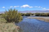 |
Долина реки Бохморон-Гол Один из рукавов реки Бохморон Гол. На берегу растет Caragana spinosa. 12.06.2017. late spring or early summer |
Text to cite the page
Скотникова М. 2017—2018. Долина реки Бохморон-Гол [географическая точка: ландшафты и сообщества] // Плантариум. Растения и лишайники России и сопредельных стран: открытый онлайн атлас и определитель растений. [Электронный ресурс] URL: https://www.plantarium.ru/page/landscapes/point/9413.html (дата обращения: 16.09.2026).
Скотникова М. 2017—2018. Долина реки Бохморон-Гол [geographic point: photos of landscapes and habitats] // Plantarium. Plants and lichens of Russia and neighboring countries: open online galleries and plant identification guide. URL: https://www.plantarium.ru/lang/en/page/landscapes/point/9413.html (accessed on 16 Sep 2026).
Plants and lichens
Participant
Search
|
|
Feedback | To the top |