Озеро Хяргас-Нуур / geographic pointLandscapes and habitats
online plant identification guide
Directories
Region
| Geographic point: | Озеро Хяргас-Нуур |
| Coordinates: | 49° 18′ 12″ N, 93° 12′ 06″ E (view at maps of Google, OpenStreetMap, Yandex) |
| Administrative location: | Монголия, аймак Увс, сомон Малчин |
| Physiographic location: | Центральная Азия, Монгольское плато, Котловина Больших Озер, берег озера Хяргас-Нуур |
| Author: | Марина Скотникова |
Images
From 1 to 4 are shown (4 of 4 found)
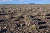 |
 Озеро Хяргас-Нуур Щебнистая пустыня с аспектом цветущих Convolvulus gortschakovii. 10.06.2017. late spring or early summer |
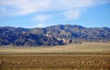 |
Озеро Хяргас-Нуур Вид на склоны хребта Хан Хухийн с северного берега озера Хяргас Нуур. 10.06.2017. late spring or early summer |
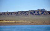 |
Озеро Хяргас-Нуур Озеро Хяргас Нуур и расположенный к северу от него хребет Хан Хухийн. 11.06.2017. late spring or early summer |
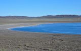 |
Озеро Хяргас-Нуур Щебнистая пустыня на северном берегу озера Хяргас Нуур. 11.06.2017. late spring or early summer |
Plants and lichens
Participant
Search
|
|
Feedback | Text to cite the page | To the top |