Перевал Пеуэнче (Pehuenche) / geographic pointLandscapes and habitats
online plant identification guide
Directories
Region
| Geographic point: | Перевал Пеуэнче (Pehuenche) |
| Coordinates: | 35° 59′ 00″ S, 70° 24′ 00″ W (view at maps of Google, OpenStreetMap, Yandex) |
| Administrative location: | Аргентина, провинция Мендоза |
| Physiographic location: | Южная Америка, Анды, Южные Анды, хребет Главная Кордильера, перевал Пеуэнче (Pehuenche) |
| Author: | Natalija Shevyreva |
Description
Граница Чили (провинция Мауле, 165 км трассы CH 115) — Аргентина (провинция Мендоза, 76 км трассы 145).
Высота 2553 м над уровнем моря. Каменистая пустыня со скалистыми выступами и небольшими ручьями. Растительность по сухим участкам разреженная в виде подушек и более плотная у ручьев на скалах.
Images
Single image is found
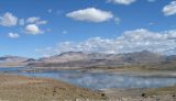 |
  Перевал Пеуэнче (Pehuenche) Озеро Мауле немного ниже перевала (на чилийской стороне). Практически ничего не растёт. 02.03.2014. late summer or early autumn |
Text to cite the page
Шевырева Н. 2017. Перевал Пеуэнче (Pehuenche) [географическая точка: ландшафты и сообщества] // Плантариум. Растения и лишайники России и сопредельных стран: открытый онлайн атлас и определитель растений. [Электронный ресурс] URL: https://www.plantarium.ru/page/landscapes/point/9311.html (дата обращения: 16.09.2026).
Shevyreva N. 2017. Перевал Пеуэнче (Pehuenche) [geographic point: photos of landscapes and habitats] // Plantarium. Plants and lichens of Russia and neighboring countries: open online galleries and plant identification guide. URL: https://www.plantarium.ru/lang/en/page/landscapes/point/9311.html (accessed on 16 Sep 2026).
Plants and lichens
Participant
Search
|
|
Feedback | To the top |