Чандыбил / geographic pointLandscapes and habitats
online plant identification guide
Directories
Region
| Geographic point: | Чандыбил |
| Coordinates: | 38° 26′ 07.12″ N, 56° 59′ 08.31″ E (view at maps of Google, OpenStreetMap, Yandex) |
| Administrative location: | Туркменистан, Ахалский велаят, этрап Бахарлы, дайханское объединение Гарры-Нохур |
| Physiographic location: | Средняя Азия и Центральный Казахстан, Балханы и Копетдаг, Копетдаг-Хорасанская горная система, хребет Копетдаг |
| Author: | Alexandr Pavlenko |
Description
Заброшенная турбаза Чандыбил находится на высоте 1200–1400 м н.у.м. в поясе арчовников и подушковидных кустарников.
Images
From 1 to 3 are shown (3 of 3 found)
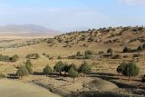 |
 Чандыбил Пояс арчовников. Конец августа 2015 г. late summer or early autumn |
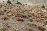 |
Чандыбил Пояс подушковидных ксерофитов - сообщество Astracantha и Acantholimon. Конец августа 2015 г. late summer or early autumn |
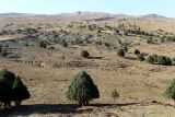 |
Чандыбил Пояс арчовников. Конец августа 2015 г. late summer or early autumn |
Text to cite the page
Павленко А.В. 2017. Чандыбил [географическая точка: ландшафты и сообщества] // Плантариум. Растения и лишайники России и сопредельных стран: открытый онлайн атлас и определитель растений. [Электронный ресурс] URL: https://www.plantarium.ru/page/landscapes/point/9103.html (дата обращения: 15.09.2026).
Pavlenko A. 2017. Чандыбил [geographic point: photos of landscapes and habitats] // Plantarium. Plants and lichens of Russia and neighboring countries: open online galleries and plant identification guide. URL: https://www.plantarium.ru/lang/en/page/landscapes/point/9103.html (accessed on 15 Sep 2026).
Plants and lichens
Participant
Search
|
|
Feedback | To the top |