Окрестности посёлка Черский / geographic pointLandscapes and habitats
online plant identification guide
Directories
Region
| Geographic point: | Окрестности посёлка Черский |
| Coordinates: | 68° 43′ 57″ N, 161° 20′ 25″ E (view at maps of Google, OpenStreetMap, Yandex) |
| Administrative location: | Россия, Республика Саха (Якутия), Нижнеколымский район |
| Physiographic location: | Северо-Восточная Сибирь, Колымская низменность |
| Author: | Pavel Krestov |
Description
Северная подзода бореальной зоны в континентальном секторе, редины лиственницы
Images
Single image is found
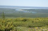 |
 Окрестности посёлка Черский Окрестности поселка Черский. Вид с горы Родинка в направлении поселка. 23.06.2007. summer |
Plants and lichens
Participant
Search
| Feedback | Text to cite the page | To the top |