Одесса, центр / geographic pointLandscapes and habitats
online plant identification guide
Directories
Region
| Geographic point: | Одесса, центр |
| Coordinates: | 46° 29′ 00″ N, 30° 44′ 07″ E (view at maps of Google, OpenStreetMap, Yandex) |
| Administrative location: | Украина, Одесская область, город Одесса |
| Physiographic location: | Восточно-Европейская равнина, Причерноморская низменность |
| Author: | Aleksei Titov |
Images
From 1 to 2 are shown (2 of 2 found)
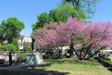 |
 Одесса, центр Цветущий багряник (Cercis siliquastrum?) в городском саду Одессы. Начало мая 2013 г. late spring or early summer |
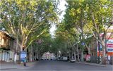 |
Одесса, центр Платаны на Ришельевской улице. Начало мая 2013 г. spring |
Text to cite the page
Титов А. 2013. Одесса, центр [географическая точка: ландшафты и сообщества] // Плантариум. Растения и лишайники России и сопредельных стран: открытый онлайн атлас и определитель растений. [Электронный ресурс] URL: https://www.plantarium.ru/page/landscapes/point/2224.html (дата обращения: 15.09.2026).
Titov A. 2013. Одесса, центр [geographic point: photos of landscapes and habitats] // Plantarium. Plants and lichens of Russia and neighboring countries: open online galleries and plant identification guide. URL: https://www.plantarium.ru/lang/en/page/landscapes/point/2224.html (accessed on 15 Sep 2026).
Plants and lichens
Participant
Search
|
|
Feedback | To the top |