Воргашор / geographic pointLandscapes and habitats
online plant identification guide
Directories
Region
| Geographic point: | Воргашор |
| Coordinates: | 66° 59′ 15″ N, 64° 13′ 23″ E (view at maps of Google, OpenStreetMap, Yandex) |
| Administrative location: | Россия, Республика Коми, городской округ Воркута |
| Physiographic location: | Урал, Полярный Урал, бассейн реки Елец, долина ручья Воргашор |
| Author: | Aleksei Titov |
Images
Single image is found
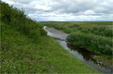 |
 Воргашор Ручей Воргашор недалеко от впадения в Елец. Слева видны заросли берёзы карликовой (Betula nana). Июль 2011 г. summer |
Plants and lichens
Participant
Search
| Feedback | Text to cite the page | To the top |