Окрестности города Камаша / geographic pointLandscapes and habitats
online plant identification guide
Directories
Region
| Geographic point: | Окрестности города Камаша |
| Coordinates: | 32° 40′ 49.83″ N, 16° 51′ 26.24″ W (view at maps of Google, OpenStreetMap, Yandex) |
| Administrative location: | Португалия, автономный регион Мадейра, муниципалитет Санта-Круш, окрестности города Камаша |
| Physiographic location: | Атлантический океан, архипелаг Мадейра, остров Мадейра |
| Author: | Марина Скотникова |
Images
From 1 to 2 are shown (2 of 2 found)
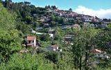 |
 Окрестности города Камаша Вид с опушки лиственного леса с Eucalyptus на окраину г. Камаша. 09.06.2026. summer |
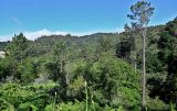 |
Окрестности города Камаша Опушка смешанного леса с Pinus в окр. г. Камаша. 09.06.2026. summer |
Plants and lichens
Participant
Search
|
|
Feedback | Text to cite the page | To the top |