Окрестности села Лазо / geographic pointLandscapes and habitats
online plant identification guide
Directories
Region
| Geographic point: | Окрестности села Лазо |
| Coordinates: | 47° 32′ 04.29″ N, 28° 03′ 13.76″ E (view at maps of Google, OpenStreetMap, Yandex) |
| Administrative location: | Республика Молдова, Сынжерейский район, окрестности села Лазо |
| Physiographic location: | Восточно-Европейская равнина, Северо-Молдавская равнина |
| Author: | Ion Chibzii |
Description
Пшеничное поле с радугой (лето, 80-тые годы).
Images
Single image is found
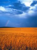 |
 Окрестности села Лазо Пшеничное поле с радугой (80-тые годы). summer |
Plants and lichens
Participant
Search
| Feedback | Text to cite the page | To the top |