Заповедник «Анжи» / geographic pointLandscapes and habitats
online plant identification guide
Directories
Region
| Geographic point: | Заповедник «Анжи» |
| Coordinates: | 21° 51′ 14.41″ S, 46° 50′ 51.67″ E (view at maps of Google, OpenStreetMap, Yandex) |
| Administrative location: | Мадагаскар, провинция Фианаранцуа, окрестности города Фианаранцуа, заповедник "Anja" |
| Physiographic location: | Африка, Восточная Африка, остров Мадагаскар |
| Author: | Вадим Должанский |
Description
Местность вокруг горы Anja, 1000-1400 метров над уровнем моря. Гранитный горный массив с многочисленными скалами, поросшие тропическим горным лесом, 02.012.2019
Images
From 1 to 4 are shown (4 of 4 found)
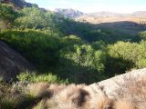 |
 Заповедник «Анжи» Лес у подошвы горы Анжи, 02.12.2019. end of dry season or early wet season |
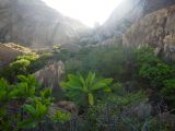 |
Заповедник «Анжи» Перевал между двух вершин горы Анжи, 02.12.2019. end of dry season or early wet season |
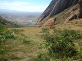 |
Заповедник «Анжи» Перевал между двух вершин горы Анжи, 02.12.2019. end of dry season or early wet season |
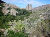 |
Заповедник «Анжи» Склоны горы Анжи, 02.12.2019. end of dry season or early wet season |
Text to cite the page
Должанский В.Ю. 2022. Заповедник «Анжи» [географическая точка: ландшафты и сообщества] // Плантариум. Растения и лишайники России и сопредельных стран: открытый онлайн атлас и определитель растений. [Электронный ресурс] URL: https://www.plantarium.ru/page/landscapes/point/11603.html (дата обращения: 17.09.2026).
Должанский В.Ю. 2022. Заповедник «Анжи» [geographic point: photos of landscapes and habitats] // Plantarium. Plants and lichens of Russia and neighboring countries: open online galleries and plant identification guide. URL: https://www.plantarium.ru/lang/en/page/landscapes/point/11603.html (accessed on 17 Sep 2026).
Plants and lichens
Participant
Search
|
|
Feedback | To the top |