Покинутое село Усур / geographic pointLandscapes and habitats
online plant identification guide
Directories
Region
| Geographic point: | Покинутое село Усур |
| Coordinates: | 41° 31′ 33.77″ N, 47° 41′ 23.01″ E (view at maps of Google, OpenStreetMap, Yandex) |
| Administrative location: | Россия, Республика Дагестан, Ахтынский район, покинутое село Усур |
| Physiographic location: | Кавказ, Большой Кавказ, Восточный Кавказ, бассейн реки Самур, бассейн реки Усуркам |
| Author: | Alexander Fateryga |
Images
From 1 to 2 are shown (2 of 2 found)
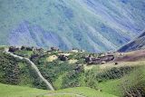 |
 Покинутое село Усур Село Усур (2040 м н.у.м.). summer |
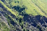 |
Покинутое село Усур Ущелье у с. Усур (1050 м н.у.м.). summer |
Plants and lichens
Participant
Search
|
|
Feedback | Text to cite the page | To the top |