Петропавловск-Камчатский / geographic pointPhotos of plants and lichens
online plant identification guide
Directories
Region
| Geographic point: | Петропавловск-Камчатский |
| Coordinates: | 53° 04′ 36″ N, 158° 38′ 32″ E (view at maps of Google, OpenStreetMap, Yandex) |
| Administrative location: | Россия, Камчатский край, Петропавловск-Камчатский городской округ, город Петропавловск-Камчатский |
| Physiographic location: | Дальний Восток, Север Дальнего Востока, полуостров Камчатка, Авачинский залив, Авачинская бухта |
| Author: | Евгений Линник |
| Description: | show |
| Links to web resources: | show |
Images
The author of the photos shown here is Yuliya Borisova. These photos are just a part of the complete set of images.
Single image is found
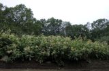 |
 Заросли цветущих растений вдоль дороги на Халактырский пляж. Камчатский край, ГО Петропавловск-Камчатский, грунтовая дорога у подножия сопки Толстый мыс. 17.08.2022. |
Plants and lichens
Participant
Search
|
|
Feedback | Text to cite the page | To the top |