Река Теза / geographic pointPhotos of plants and lichens
online plant identification guide
Directories
Region
| Geographic point: | Река Теза |
| Coordinates: | 56° 47′ 24″ N, 41° 22′ 08″ E (view at maps of Google, OpenStreetMap, Yandex) |
| Administrative location: | Россия, Ивановская область, Шуйский район |
| Physiographic location: | Восточно-Европейская равнина, бассейн реки Волга, бассейн реки Ока, бассейн реки Клязьма, бассейн реки Теза, долина реки Теза;Восточно-Европейская равнина, Волжско-Окское междуречье |
| Author: | Vladimir Papchenkov |
| Description: | show |
Images
From 1 to 2 are shown (2 of 2 found)
 |
 Проростки. Ивановская обл., окр. г. Шуя, р. Теза. 09.07.2010. |
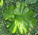 |
Погруженный гофрированный лист. Ивановская обл., окр. г. Шуя, р. Теза. 09.07.2010. |
Plants and lichens
Participant
Search
| Feedback | Text to cite the page | To the top |