Река Бага-Ойгур / geographic pointPhotos of plants and lichens
online plant identification guide
Directories
Region
| Geographic point: | Река Бага-Ойгур |
| Coordinates: | 49° 18′ 26.64″ N, 88° 32′ 09.96″ E (view at maps of Google, OpenStreetMap, Yandex) |
| Administrative location: | Монголия, аймак Баян-Улгий |
| Physiographic location: | Горы Южной Сибири, Алтай, Монгольский Алтай, бассейн реки Бага-Ойгур |
| Author: | Татьяна Казаковцева |
Images
Single image is found
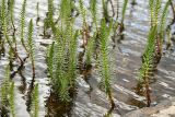 |
 Вегетирующие растения. Монголия, аймак Баян-Улгий, берег р. Бага-Ойгур, ≈ 2000 м н.у.м. 09.08.2025. |
Plants and lichens
Participant
Search
| Feedback | Text to cite the page | To the top |