Чуфут-Кале / geographic pointLandscapes and habitats
online plant identification guide
Directories
Region
| Geographic point: | Чуфут-Кале |
| Coordinates: | 44° 44′ 27″ N, 33° 55′ 28″ E (view at maps of Google, OpenStreetMap, Yandex) |
| Administrative location: | Россия, Республика Крым, Бахчисарайский район • Россия, Республика Крым, Бахчисарайский район, городское поселение Бахчисарай |
| Physiographic location: | Средиземноморье и Переднеазиатские нагорья, Горный Крым, Крымское предгорье, Внутренняя гряда • Средиземноморье и Переднеазиатские нагорья, Горный Крым, Крымское предгорье, Внутренняя гряда, урочище Чуфут-Кале |
| Author: | Maxim Vladimirovich |
Description
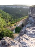
Небольшое плато на вершине скалы 2,5 км к востоку от Бахчисарая, частично занятое древним разрушенным пещерным городом Чуфут-Кале. Скальный грунт.
Images
The author of the photos shown here is Оксана Великова. These photos are just a part of the complete set of images.
Single image is found
 |
Чуфут-Кале Вид с Чуфут-Кале. 17.08.2008. summer |
Text to cite the page
Гуляев М.В., Борисова Ю., Буланов С., Великова О., Лебедев А., Проснев С., Скотникова М. 2016. Чуфут-Кале [географическая точка: ландшафты и сообщества] // Плантариум. Растения и лишайники России и сопредельных стран: открытый онлайн атлас и определитель растений. [Электронный ресурс] URL: https://www.plantarium.ru/page/landscapes/point/8437.html (дата обращения: 31.12.2025).
Vladimirovich M., Borisova Y., Bulanov S., Великова О., Лебедев А., Проснев С., Скотникова М. 2016. Чуфут-Кале [geographic point: photos of landscapes and habitats] // Plantarium. Plants and lichens of Russia and neighboring countries: open online galleries and plant identification guide. URL: https://www.plantarium.ru/lang/en/page/landscapes/point/8437.html (accessed on 31 Dec 2025).
Plants and lichens
Participant
Search
|
|
Feedback | To the top |