Казань / geographic pointLandscapes and habitats
online plant identification guide
Directories
Region
| Geographic point: | Казань |
| Coordinates: | 55° 47′ 25.55″ N, 49° 07′ 16.22″ E (view at maps of Google, OpenStreetMap, Yandex) |
| Administrative location: | Россия, Республика Татарстан, город Казань |
| Physiographic location: | Восточно-Европейская равнина, бассейн реки Волга, долина реки Волга |
| Author: | Vadim Prokhorov |
Images
The author of the photos shown here is Mariia Novikova. These photos are just a part of the complete set of images.
From 1 to 2 are shown (2 of 2 found)
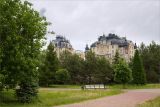 |
 Казань Парк земледельцев, засаженный преимущественно хвойными деревьям, в составе - кипарис (Cupressus), пихта (Abies), ель (Picea), сосна (Pinus), с участием липы (Tilia). 21.05.2026. summer |
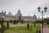 |
 Казань Дворец земледельцев с 20-метровым бронзовым деревом в центральной арке. Перед дворцом разбит сквер под названием "Парк земледельцев", в составе зелёных насаждений - хвойные (Cupressus, Picea, Pinus) и лиственные (с Tilia) деревья. 31.05.2026. summer |
Plants and lichens
Participant
Search
| Feedback | Text to cite the page | To the top |