Голубое озеро / geographic pointLandscapes and habitats
online plant identification guide
Directories
Region
| Geographic point: | Голубое озеро |
| Coordinates: | 43° 20′ 43″ N, 40° 24′ 42″ E (view at maps of Google, OpenStreetMap, Yandex) |
| Administrative location: | Абхазия, Гагрский район |
| Physiographic location: | Кавказ, Большой Кавказ, Западный Кавказ, Бзыбское ущелье |
| Author: | Nikolay Degtyaryov |
Images
The author of the photos shown here is Mariia Novikova. These photos are just a part of the complete set of images.
From 1 to 2 are shown (2 of 2 found)
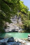 |
 Голубое озеро Голубое озеро карстового происхождения, площадью 180 м². Питание происходит подземным потоком воды, начинающимся на склонах высокой горы Ахцых; уходящий поток впадает в реку Бзыбь. 13.05.2021. late spring or early summer |
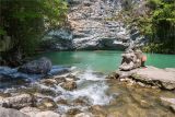 |
Голубое озеро Голубое озеро - небольшое, но очень глубокое (до 76 метров), вода холодная и не прогревается выше 10 градусов. Животный мир (рыба, планктон) и водные растения отсутствуют. 13.05.2021. late spring or early summer |
Links to web resources
www.tourister.ru/world/europe/abkhazija/city/gagra/lakes/16726
Памятка для туристов
Plants and lichens
Participant
Search
|
|
Feedback | Text to cite the page | To the top |