Мюссерская возвышенность / geographic pointLandscapes and habitats
online plant identification guide
Directories
Region
| Geographic point: | Мюссерская возвышенность |
| Coordinates: | 43° 10′ 34″ N, 40° 24′ 40″ E (view at maps of Google, OpenStreetMap, Yandex) |
| Administrative location: | Абхазия, Гагрский район;Абхазия, Гудаутский район |
| Physiographic location: | Средиземноморье и Переднеазиатские нагорья, Армянское нагорье и Закавказье, Рионо-Куринская депрессия |
| Author: | Gennadiy Okatov |
Images
The author of the photos shown here is Игорь Павлов. These photos are just a part of the complete set of images.
From 1 to 2 are shown (2 of 2 found)
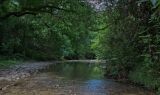 |
 Мюссерская возвышенность Долина реки Риапши. Вдоль берегов, кроны Pterocarya pterocarpa, Carpinus betulus и свисающие побеги Smilax excelsa. 17.08.2013. summer |
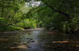 |
Мюссерская возвышенность Долина реки Риапши. Вдоль берегов, кроны Pterocarya pterocarpa, Carpinus betulus и свисающие побеги Smilax excelsa. 17.08.2013. summer |
Plants and lichens
Participant
Search
|
|
Feedback | Text to cite the page | To the top |