Ущелье Гара-Баши / geographic pointLandscapes and habitats
online plant identification guide
Directories
Region
| Geographic point: | Ущелье Гара-Баши |
| Coordinates: | 43° 16′ 30″ N, 42° 29′ 02″ E (view at maps of Google, OpenStreetMap, Yandex) |
| Administrative location: | Россия, Кабардино-Балкарская Республика, Эльбрусский район |
| Physiographic location: | Кавказ, Большой Кавказ, Боковой хребет, гора Эльбрус, ущелье Гара-Баши |
| Author: | Irina Tabunova |
Description
Основание ущелья Гара-Баши состоит из кристаллических сланцев, которые выступают на поверхность в местах камнепадов и деятельности человека. Большая часть склонов ущелья покрыта альпийскими лугами.
Images
The author of the photos shown here is Александр Лебедев. These photos are just a part of the complete set of images.
Single image is found
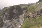 |
 Ущелье Гара-Баши Правый исток реки Гара-Баши. Конец июня 2002 г. summer |
Plants and lichens
Participant
Search
|
|
Feedback | Text to cite the page | To the top |