Края полей под Мелитополем / geographic pointLandscapes and habitats
online plant identification guide
Directories
Region
| Geographic point: | Края полей под Мелитополем |
| Coordinates: | 46° 45′ 14″ N, 35° 14′ 30″ E (view at maps of Google, OpenStreetMap, Yandex) |
| Administrative location: | Украина, Запорожская область, Мелитопольский район |
| Physiographic location: | Восточно-Европейская равнина, Приазовская низменность |
| Author: | Denis Mirin |
Description
Края полей и лесополосы между ними вдоль магистрали М18 к югу от Мелитополя.
Images
The author of the photos shown here is Yuri Pirogov. These photos are just a part of the complete set of images.
Single image is found
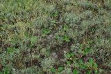 |
  Края полей под Мелитополем Кострово-кермеково-полынное галофитное сообщество на солонце в пойме реки Молочной. 17.05.2012. late spring or early summer |
Plants and lichens
Participant
Search
|
|
Feedback | Text to cite the page | To the top |