Салехард / geographic pointLandscapes and habitats
online plant identification guide
Directories
Region
| Geographic point: | Салехард |
| Coordinates: | 66° 32′ 41.02″ N, 66° 36′ 03.5″ E (view at maps of Google, OpenStreetMap, Yandex) |
| Administrative location: | Россия, Ямало-Ненецкий Автономный Округ, Приуральский район, город Салехард |
| Physiographic location: | Западно-Сибирская равнина, бассейн реки Обь, долина реки Обь |
| Author: | Maria Kozlova |
Images
The author of the photos shown here is Lena Glazunova. These photos are just a part of the complete set of images.
Single image is found
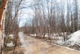 |
 Салехард Смешанный берёзово-лиственничный лес с примесью ели в начале июня только начинает просыпаться после долгой зимы. ЯНАО, окр. г. Салехард, рядом с паромной переправой через р. Обь. 07.06.2024. spring |
Plants and lichens
Participant
Search
|
|
Feedback | Text to cite the page | To the top |