Окрестности Бол. Азишской пещеры / geographic pointLandscapes and habitats
online plant identification guide
Directories
Region
| Geographic point: | Окрестности Бол. Азишской пещеры |
| Coordinates: | 44° 07′ 10.9″ N, 40° 01′ 55.1″ E (view at maps of Google, OpenStreetMap, Yandex) |
| Administrative location: | Россия, Республика Адыгея, Майкопский район |
| Physiographic location: | Кавказ, Большой Кавказ, Западный Кавказ, бассейн реки Кубань, бассейн реки Белая |
| Author: | Александр Лебедев |
Images
The author of the photos shown here is Артем Федоровцев. These photos are just a part of the complete set of images.
Single image is found
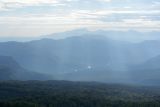 |
 Окрестности Бол. Азишской пещеры С края скалы видна р. Белая и расположенное на левом берегу село Хамышки. На горизонте вздымается гора Большой Тхач. 16.09.2023. late summer or early autumn |
Plants and lichens
Participant
Search
|
|
Feedback | Text to cite the page | To the top |