Бабуган / geographic pointPhotos of plants and lichens
online plant identification guide
Directories
Region
| Geographic point: | Бабуган |
| Coordinates: | 44° 37′ 00″ N, 34° 16′ 00″ E (view at maps of Google, OpenStreetMap, Yandex) |
| Administrative location: | Россия, Республика Крым, городской округ Алушта |
| Physiographic location: | Средиземноморье и Переднеазиатские нагорья, Горный Крым, Главная гряда, Бабуган-Яйла |
| Author: | Pavel Yevseyenkov |
| Description: | show |
Images
The author of the photos shown here is Ирина Гайворонская. These photos are just a part of the complete set of images.
From 1 to 2 are shown (2 of 2 found)
 |
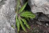
Растение среди камней. Крым, Бабуган-яйла, подножие горы Зейтин-Кош. 3 мая 2019 г. |
 |
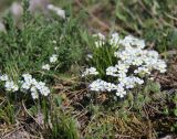
Цветущие растения. Крым, Бабуган-яйла, окр. вершины Куш-Кая. 5 мая 2013 г. |
Text to cite the page
Евсеенков П., Гайворонская И.Ю., Саплицкая Л. 2011. Бабуган [географическая точка: фотографии растений и лишайников] // Плантариум. Растения и лишайники России и сопредельных стран: открытый онлайн атлас и определитель растений. [Электронный ресурс] URL: https://www.plantarium.ru/page/dwellers/point/817.html (дата обращения: 17.01.2026).
Yevseyenkov P., Гайворонская И.Ю., Саплицкая Л. 2011. Бабуган [geographic point: photos of plants and lichens] // Plantarium. Plants and lichens of Russia and neighboring countries: open online galleries and plant identification guide. URL: https://www.plantarium.ru/lang/en/page/dwellers/point/817.html (accessed on 17 Jan 2026).
Plants and lichens
Participant
Search
|
|
Feedback | To the top |