Перевал Кату-Ярык / geographic pointPhotos of plants and lichens
online plant identification guide
Directories
Region
| Geographic point: | Перевал Кату-Ярык |
| Coordinates: | 50° 54′ 49″ N, 88° 12′ 55″ E (view at maps of Google, OpenStreetMap, Yandex) |
| Administrative location: | Россия, Республика Алтай, Улаганский район |
| Physiographic location: | горы Южной Сибири, Алтай, Восточный Алтай, Улаганское плато, долина реки Чулышман;горы Южной Сибири, Алтай, Юго-Восточный Алтай, Чулышманский хребет, перевал Кату-Ярык |
| Author: | Марина Скотникова |
| Description: | show |
Images
The author of the photos shown here is Petr Kosachev. These photos are just a part of the complete set of images.
Single image is found
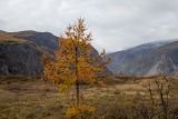 |
  Молодое дерево с шишками и с осенней хвоей. Республика Алтай, Улаганский р-н, перевал Кату-Ярык близ дол. р. Чулышман. 01.10.2020. |
Plants and lichens
Participant
Search
|
|
Feedback | Text to cite the page | To the top |