Арабатская стрелка / geographic pointPhotos of plants and lichens
online plant identification guide
Directories
Region
| Geographic point: | Арабатская стрелка |
| Coordinates: | 45° 18′ 00″ N, 35° 28′ 00″ E (view at maps of Google, OpenStreetMap, Yandex) |
| Administrative location: | Россия, Республика Крым, Ленинский район, Семисотское сельское поселение |
| Physiographic location: | Восточно-Европейская равнина, Равнинный Крым, коса Арабатская стрелка |
| Author: | Denis Mirin |
Images
The author of the photos shown here is Александр Бронсков. These photos are just a part of the complete set of images.
Single image is found
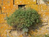 |
 Плодоносящее растение на стенах крепости Арабат. Крым, основание Арабатской стрелки. 09.08.2010. |
Plants and lichens
Participant
Search
|
|
Feedback | Text to cite the page | To the top |